RMUS Optical Gas Imaging (OGI) Package

NDAA Compliant OGI Solution

RMUS Optical Gas Imaging (OGI) Package

NDAA Compliant OGI Solution

Product Description

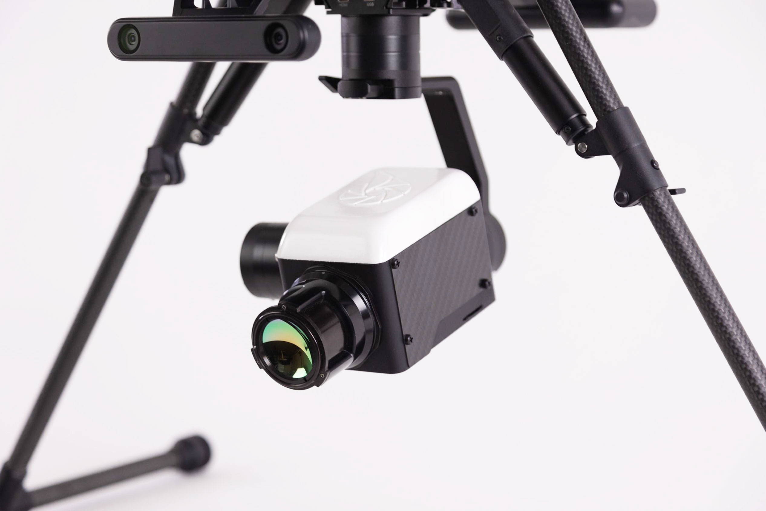
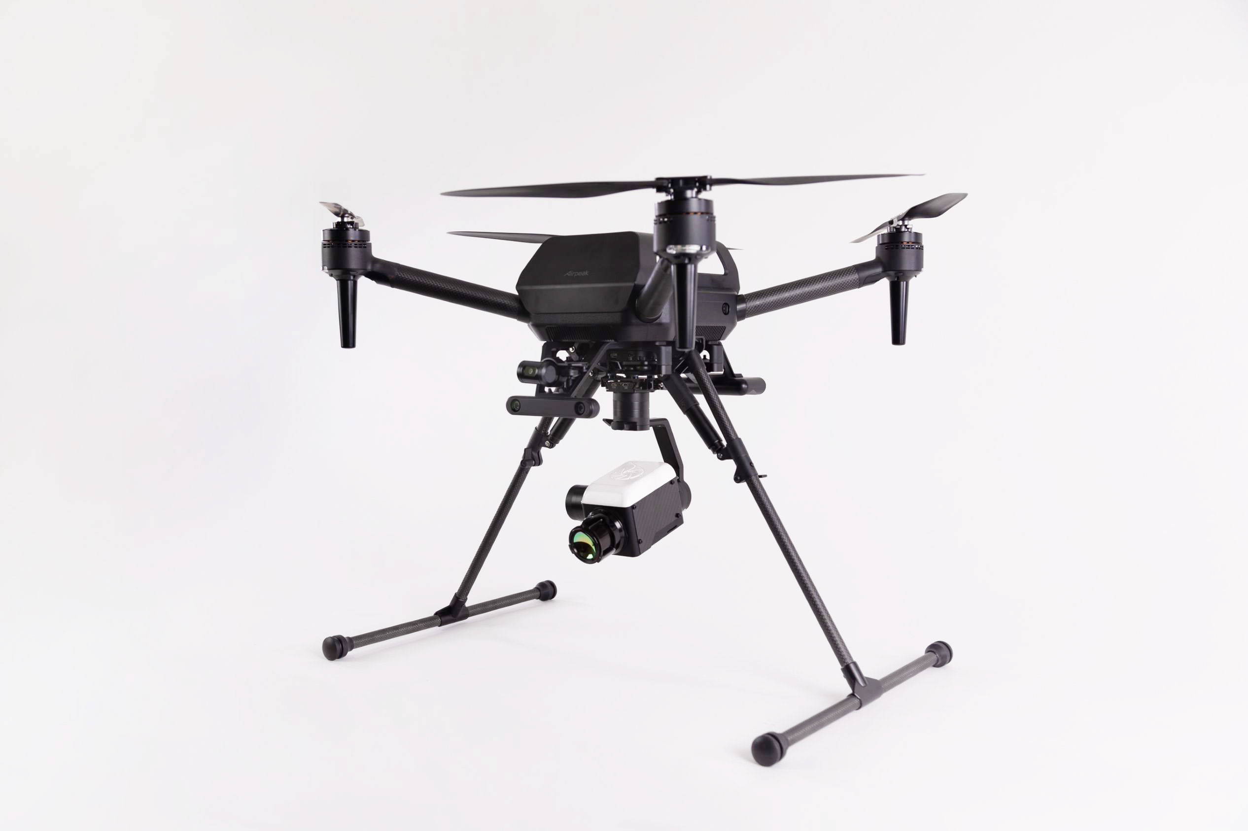
The RMUS Optical Gas Imaging (OGI) package includes all the relevant hardware, software and accessories for professional-level inspection work. After vetting numerous UAS options, we selected the Sony Airpeak S1 Enterprise system for the drone platform of the package. With its high payload tolerance and NDAA complaint manufacturing, the Airpeak S1 Enterprise is an excellent platform for this application and is supported by Sony, one of the biggest names in electronics.


The RMUS OGI payload is the result of a combined effort between RMUS, Aerial Thermal Imaging and Sierra Olympia. Aerial Thermal Imaging provided the sensor integration and AerialOGI™ reporting software, so that the workflow is easy and the deliverables are automatically created for the client. This means you spend less time tinkering with software and more time on paying jobs. The Sierra Olympia Ventus OGI core is the sensor workhorse of this payload, providing high resolution imagery of potential leaks and other anomalies.


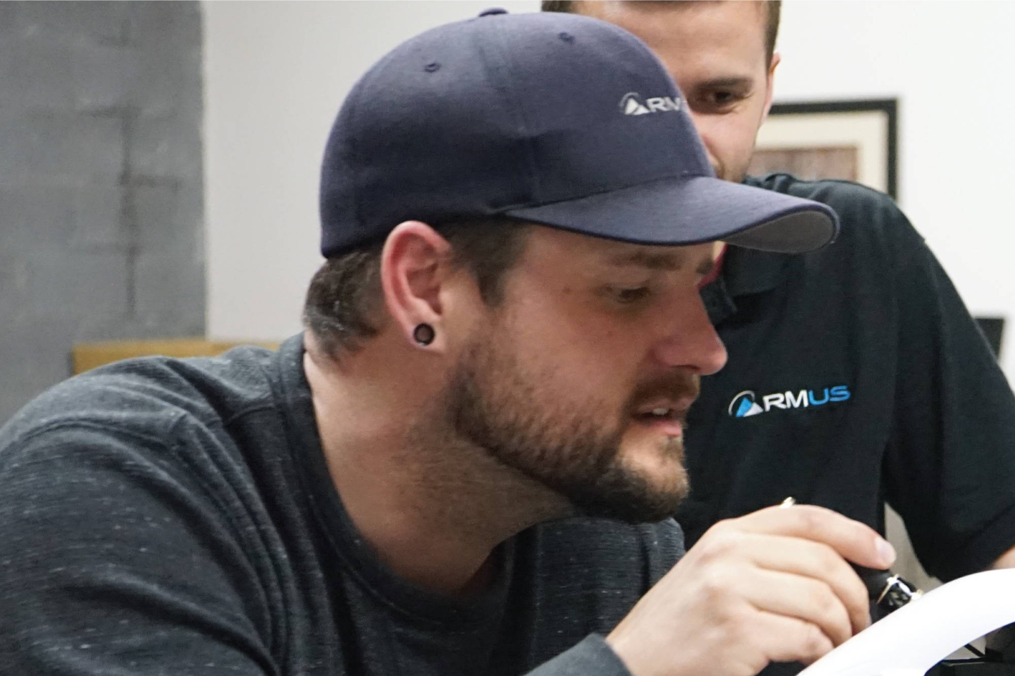
The RMUS OGI package includes all of the hardware, software and training so that you can get operational and booking jobs ASAP. We highly encourage you to call one of our Sales Reps at 800-739-8393 for any questions you may have.


RTK flight accuracy and high precision data acquisition

Multiple configurations for use with included base station or GNSS correction data service

Supporting both network-type and base station type RTK as well as PPK logging provides use in a wide variety of work environments.


Enables recording of positioning information with accuracy within a few centimeters

RTK enables accurate positioning with accuracy within a few centimeters, compared with GNSS with accuracy within a few meters. The positioning information is synchronized with high precision with the timing of image data capture, and the recorded position is offset to the center of the image sensor.

Stable flight even with strong magnetic field interference

Two GNSS antennas enable stable flight even in an environment where the geomagnetic sensor may affect the aircraft’s control due to the influence of inspection objects or surrounding structures.

Accurate flight with low-error self-position estimation

Self-position estimation with less error is achieved by using RTK in conjunction with vision sensors, improving aircraft handling during deceleration, hovering stability, and automatic flight accuracy. By using Direct Repeat Flight, periodic inspection flows can be reproduced as many times as desired with high accuracy, enabling efficient and highly accurate operations that do not depend on operator skill.


RTK flight accuracy and high precision data acquisition

High wind resistance to prevent being swept away by strong winds

Sony-developed propulsion devices such as propellers, motors, and ESCs, as well as the flight controller achieve wind resistance of up to 44.7 mph (20m/s)*. The aircraft resists being swept away by erratic winds at high altitudes and is stable even in strong winds at coasts and in canyons.


*Without payload

Supports long automated flights

Supports the ability to resume automated flight after it has been interrupted mid-flight, and battery hot-swapping, which allows battery replacement while the aircraft is powered on. Achieves approximately 20 minutes* of flight time while equipped with RTK and high-resolution camera.


*When equipped with LBP-HM1, RTK-1, GBL-PX1, Alpha 7R IV A, FE 35mm F2.8 Zeiss, cruising speed(9m/s) , sea level, no wind


AerialOGI™ Reporting Software

AerialOGI takes pride in offering a comprehensive reporting solution workflow. Your assigned pilot conducts aerial inspections of refineries, array of wellheads, pipelines, or other infrastructure, with a focus on detecting and reporting leaks across numerous locations. By utilizing the AerialOGI Reporting Tool, the pilot can prioritize safety and efficiency. This tool enables efficient sorting of hours of collected video, identifying relevant capture events that can be exported to your LDAR (Leak Detection and Repair) software.

During the flight, as the pilot prioritizes safety and completes all survey items, any observed leaks can be easily documented by pressing the capture button. It is highly recommended to record the entire flight, allowing for the initiation of a capture event whenever a leak is observed. Once all survey points are completed, the pilot can add the entire video collection to our reporting tool. This tool accurately identifies the precise moment when the capture button was pressed, generating an incident on our web portal and presenting actionable data.

Each capture event includes a Flat Field Correction (FFC) for the Optical Gas Imaging camera, ensuring the highest quality data is captured during the leak observation. All capture events are displayed on the web portal, providing the option to manually input data into your LDAR software. Alternatively, if you have our advanced bridge enabled, the web portal generates an instant export feature to seamlessly transfer the data to your LDAR software.

This is a capture event where a pilot observes a leak and then presses the Capture button. When this happens, the Optical Gas Imaging camera quickly calibrates to ensure the best video and data capture, and then starts the video notation event. The Capture button can be pressed as many times as needed during a flight and can be easily sorted into actionable data using our AerialOGI Reporting Tool.


RMUS OGI Payload Specs

FOCAL PLANE ARRAY

Resolution:

640 x 512


Sensor:

IDC InAsSb-based


Pitch:

15μm


Wavelength:

3.2 - 3.42 μm


NETD:

<28mK


Framerate:

30Hz

OPTICS, SIZE, AND WEIGHT

Part Number:

SL-VG63-025-00 


Focal Length:

25mm


HFOV: 

21.7°F#1.5


Weight: 

(approx)586g (1.3lb)


Envelope Dimensions (LxWxH): 

(approx)148 x 69 x 73mm5.8 x 2.7 x 2.9in


Digital Zoom:

8x

INTERFACE

Analog Video Output:

NTSC/PAL


Digital Video Output:

14-bit CameraLink


Command and Control:

RS422 / CameraLink serial


Power Consumption:

12VDC / 6W typ

12W peak

ENVIRONMENTAL

Operating Temperature Range:

-35 to +65C


Mounting:

¼-20 Tripod Mount, M4 Tapped Holes


Certification:

OOOOa Certified (<= 60 g/hr)

DETECTABLE GASES

Acetic Acid, Ammonia, Benzene, Butadiene, Butane, Ethane, Ethylbenzene , Ethylene, Heptane, Hexane, Isoprene, Methyl Ethyl Ketone (MEK), Methane, Methanol, MIBK, Octane, 1-Pentane, Propane, Propylene, Sulphur Dioxide, Toluene, Vinyl Chloride and Xylene.

ADDITIONAL FEATURES

OGI Optimized Lens

Shutter and Scene-based NUC

Automatic/Manual Gain Control

Local Area Processed Dynamic Contrast Enhancement

Foreground/Background Contrast Enhancement

Digital noise reduction

Multiple color palettes / LUT

Symbology Overlay

Simultaneous analog/digital output

EXPORT CLASSIFICATION

EAR 6A003.b.4.a

APPLICATIONS

Systems integrators

Pipe racks

Gathering and Transmission lines

Above and below ground gas pipelines

Fuel Gas Line

Valves

Flanges

Connections

Seals

Vent stacks

Compressors

Storage Tanks 

and more...

Sony Airpeak S1 at a glance

Max Flight Time

30 min

(no payload)
20 min with RTK-1, GBL-PX1, ILCE-7RM4A and SEL35F28Z payload

Max Speed

25 m/s

(55.9 mph) without payload, obstacle brake disabled

Weight

6 lb

Main unit only, no batteries

Service Ceiling

8,202 ft

2500 m

Sony Airpeak S1 Enterprise Specs

Size

Dimensions:

Main unit only: Approx. 20.75(H) x 23.38(W) x 20.25(D) inches*1 *2

When the RTK kit is attached to the aircraft: Approx. 21.25(H) x 23.38(W) x 20.25(D) inches*1 *2


*1 Landing position, without propellers

*2 Approx. 39.88(W) inch(Landing gear is up)


Diagonal Wheelbase:

Approx. 25.5 inch (without propellers)

Weight

Aircraft Weight

Main unit only*: Approx. 6 lb 14.9 oz

When the RTK kit is attached to the aircraft*: Approx. 7 lb 7.2 oz (with GBL-T3 gimbal), Approx. 7 lb 6.9 oz (with GBL-PX1 gimbal)


* Without battery packs


Max Payload:

Approx. 5 lb 9.4 oz


Max Takeoff  Weight:

When using Battery Pack LBP-HS1: Approx. 15 lb 5.7 oz

When using Battery Pack LBP-HM1: Approx. 16lb 7.0 oz

Flight Speed

Max Speed:

25 m/s (55.9 mph) without payload, obstacle brake disabled


Max Ascent Speed:

7 m/s (without payload, obstacle brake disabled)


Max Descent Speed:

4 m/s (without payload, obstacle brake disabled)


Acceleration:

Approx. 3.5 seconds (from 0 to 49.7 mph, without payload)

Flight Control

Max Angular Velocity:

Pitch: 180°/s, Yaw: 180°/s, Roll:180°/s (Vision Positioning disabled)


Max Pitch Angle:

55° (Obstacle brake disabled), 35° (Obstacle brake enabled)

Operational Limit

Max Wind Resistance:

20m/s (44.7 mph) (without payload)


Max Gust Resistance*:

15m/s (33.6 mph) (with maximum payload)

* The maximum wind speed at which the travel distance is 1 m or less when receiving a gust from the side during straight flight.


Max Service Ceiling:

8,202 ft(Above Sea Level)


Operating Temperature:

14~104 ℉

Flight Time

Max Flight Time*:

When using Battery Pack LBP-HM1

Approx. 30 minutes(without payload)

Approx. 20 minutes(with RTK-1, GBL-PX1, ILCE-7RM4A and SEL35F28Z)

Approx. 16 minutes(with maximum payload)


When using Battery Pack LBP-HS1

Approx. 22 minutes(without payload)

Approx. 12 minutes(with maximum payload)


*Cruising speed(9m/s), sea level, no wind

Hovering Accuracy

Hovering Accuracy Range:

When the RTK kit is attached to the aircraft(RTK Kit is sold separately)

Vertical:±0.3 ft, Horizontal:±0.3ft(RTK and Vision Positioning enabled)

Vertical:±0.3ft, Horizontal:±0.3ft(GNSS* and Vision Positioning enabled)

Vertical:±1.6ft, Horizontal:±1.6ft(GNSS* enabled and Vision Positioning disabled)

*When not using the RTK function of the RTK kit and performing GNSS single point positioning


Main unit only

Vertical:±0.3ft, Horizontal:±0.3ft(GNSS and Vision Positioning enabled)

Vertical:±1.6ft, Horizontal:±4.9ft(GNSS enabled and Vision Positioning disabled)

Transmission

Operating Frequency:

2.4 – 2.4835 GHz, 5.15 – 5.25 GHz, 5.725 – 5.82 GHz


EIRP:

2.4 – 2.4835 GHz:23.8 dBm, 5.15 – 5.25 GHz:18 dBm, 5.725 – 5.82 GHz:25.6 dBm


Max Transmitting Distance:

2.4 - 2.4835 GHz:1.2 mile

5.15 - 5.25 GHz:0.6 mile

5.725 - 5.82 Ghz:1.2 mile

*Unobstructed, free of interference

Propeller

Model:

PPL1785


Propeller Size:

17 inch

Landing Gear

Landing Gear Position:

Raise and lower

GNSS

GNSS

GPS, GLONASS, QZSS

Sensor

Vision Sensor:

Method: Stereo camera

Direction: Front, back, right, left and downward directions

Operating Environment:Surfaces with clear patterns and adequate lighting

Sensing Range, FOV:1.6 - 177.2 ft, HFOV&VFOV 80°


Infrared Range Sensor:

Method:Infrared, Direction:Up and downward directions

Sensing Range, FOV:0.3 - 6.6 ft、FOV ±20°

FPV Camera

Image Sensor:

1/4 inch 8.17 Mpx CMOS Sensor


Max Frame Rate:

30 fps


FOV:

DFOV 120°


Gimbal Axis:

2 Axises Gimbal (Tilt, Roll)

Package Contents

Package:

ContentsAirpeak S1×1

Landing Gear×2

Battery Pack LBP-HS1 ×2

Battery Charger LBG-H1×1 (includes AC Adapter, Power Code) Propeller PPL1785×2 (Propeller CW ×2、Propeller CCW ×2)

Calibration Board ×1

Remote Controller RCR-VH1×1 (includes AC Adapter, Power Code)

Power Cable (Aircraft - Gimbal)×1

Control Cable (Aircraft - Gimbal)×1

USB Type-C Cable (Aircraft - Gimbal)×1

Micro USB Cable (Gimbal - Camera) ×1

USB Type-C Cable (Gimbal - Camera) ×1

Camera & Lens Compatibility

Camera:

ILCE-7M4・ILCE-7RM4A・ILCE-1・ILME-FX3・ILCE-7C・ILCE-9M2・ILCE-7SM3・ILCE-7RM4・ILCE-7RM3・ILCE-7M3・ILCE-9*


Lens:

SELP1635G・SEL14F18GM・SEL20F18G・SEL24F14GM・SEL24F28G・SEL28F20・SEL35F28Z・SEL35F18F・SEL40F25G・SEL50F25G・SEL50F18F・SEL50M28・SEL55F18Z・SEL85F18


Notes:

Use with camera systems (lens filter, hood etc.) weighing less than 1.1 kg.

-When shooting with a wide-angled lens, the aircraft may partly obstruct the shot. Compatible with lens length up to 100 mm to avoid contact with the landing gear or the ground.

-When connecting the camera to the gimbal, use a USB-C cable for USB-C port models. You may need to change the cable pull-out direction, or extend the cable length with certain lenses.

- Some features may not be available with certain camera models or firmware versions.

Gimbal Compatibility

Gimbal:

GBL-T3 (Gremsy Gimbal), GBL-PX1 (Gremsy Gimbal)

Compatible Camera Systems

Using with GBL-T3 gimbal

Use with camera systems (lens filter, hood etc.) weighing less than 1.1 kg. When attached RTK kit on the aircraft, camera systems (lens filter, hood etc.) weigh less than 0.9kg. Use with payload under maximum payload weight.


<Compatible Cameras *1 *2>

ILCE-7RM5・ILCE-7M4・ILCE-7RM4A・ILCE-1・ILME-FX3・ILCE-7C・ILCE-9M2・ILCE-7SM3・ILCE-7RM4・ILCE-7RM3 ・ILCE-7M3・ILCE-9


<Compatible Lenses *3>

Use with lens (including lens filter, hood etc.) weighing less than 460 g. Compatible with lens length up to 100 mm to avoid contact with the landing gear or the ground.


• The following lenses support gimbal presets in the Airpeak Flight app. *4

SELP1635G・SEL14F18GM・SEL20F18G・SEL24F14GM・SEL24F28G・SEL28F20・SEL35F28Z・SEL35F18F・SEL40F25G・SEL50F25G・SEL50F18F・SEL50M28・SEL55F18Z・SEL85F18


Using with GBL-PX1 gimbal

<Compatible Cameras *1 *2>

ILCE-7RM5・ILCE-7RM4A・ILCE-7RM4


<Compatible Lenses *3>

• Use with lens (including lens filter, hood etc.) weighing less than 180g. Compatible with lens length up to 70 mm.

• The following lenses support gimbal presets in the Airpeak Flight app. *4

SEL24F28G・SEL35F18F・SEL40F25G・SEL50F25G


Notes:

*1 When connecting the camera to the gimbal, use a USB-C cable for USB-C port models. You may need to change the cable pull-out direction or extend the cable length with certain lenses.

*2 Some features may not be available with certain camera models or firmware versions.

*3 When shooting with a wide-angled lens, the aircraft may partly obstruct the shot.

*4 Individual parameters can be set for lenses that do not support gimbal motor presets.


RMUS 360 Solution

Certified Technicians

RMUS employs a team of certified technicians that oversee each RMUS OGI Package. They perform a highly detailed inspection, calibration and testing process on each RMUS OGI Package.

Ready-to-Deploy Package

RMUS leverages our experience in multiple industries to create “Ready-to-Deploy” packages that include all the necessary hardware, software, and auxiliary items for successful field operations.


RMUS OGI Package Training Package

RMUS includes a complimentary online training class with every RMUS OGI Package package to ensure that our customers have a strong understanding of the platform and payload.
 

Why purchase the from RMUS?

Contracts - Sourcewell and State Contracts to expedite the purchasing process

Experience - RMUS is celebrating our 10 year anniversary in 2024. 
RMUS HUB - Online training, operator certification tracking and documentation to supplement clients' existing training programs.
Virtual Demos - Our team meets with your decision makers for final approval of purchase. This method has proven to get product in your hands much faster.
Reputation - RMUS is known globally for innovations, advice and client support.


Call us at 800 793 3548 to speak to one of our Sales Representatives


Name:

Phone:

Email:

Company/Agency Name:

Product of Interest:

Message:


RMUS Optical Gas Imaging (OGI) Package